Flagstaff Demographics
Schultz Fire, Timberline, Fernwood & Doney Park Fire & FLOOD MAP
Some facts and history of Flagstaff, Arizona
Flagstaff, Arizona (population in 2010, 65,870) is 7,000 feet above sea level and we are surrounded by the largest ponderosa pine tree forest in the world. We are located in Coconino county which is the second largest county in the United States. Flagstaff was named on Independence Day, 1876, when a centennial flag was flown from the tallest pine tree. This was supposed to have been a guide to travelers. It became a town in 1894. It was incorporated as a city in 1928. It has been the county seat of Coconino County since 1891. Flagstaff was originally a cow and lumber town and the base of many logging operations. In winter there is skiing, ice skating and hunting. Flagstaff is located along an old wagon road to California. Flagstaff began after the railroad arrived in 1881. Today Flagstaff links major routes I-40 to I-17, Highway 89 to Page and Utah, and Highway 180 to the Grand Canyon. Historic Route 66 passes through Flagstaff. Flagstaff is also the home of Northern Arizona University.
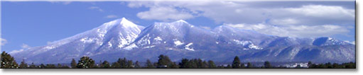
Our mountains: The beautiful
San Francisco Peaks were named in honor of Saint Francis
of Assisi. It was the teachings of St. Francis that
inspired the practice of 'traveling' friars. Francis
also taught that nature was to be observed and admired.
In this vast desert of New Spain, the Peaks stood out
as an oasis of hope and inspiration. When the Franciscan
monks established Spanish missions in the Hopi villages
of Northern Arizona, they named the jagged holy mountain
after the 13th Century friar.
The Peaks are the remnants of a composite volcano that built up to a height of sixteen thousand feet, five million years ago. In a cataclysmic landslide one half million years ago, the eastern slope gave way to its final eruption creating the multiple peaks, the inner basin and Lockett Meadow. Mt. St. Helen in Washington State is considered the Sister Mountain because of the similar nature of its recent eruption.
The San Francisco Mountains are made up of several major peaks with many smaller ones scattered at its base. The highest peak is Mt. Humphrey, which is named in honor of Brig. Gen. Andrew A. Humphrey. It is the highest point in Arizona at 12,633-ft. Mt. Agassiz, 12,356 ft., was named after Jean Louis Rodolphe Agassiz, a Zoologist at Harvard who made fossil studies for the railroad. Fremont peak, 11,969 ft., was named for John C. Fremont who was appointed Arizona’s Territorial Governor in 1878. The next peak to the east is Doyle Peak. Allen Doyle brought one of the first cattle herds here from Prescott and later became a guide for Zane Gray.
|
|
Sierra Sin Agua is a Spanish term used for the San Francisco Peaks because it is a mountain with no permanent streams. (Sierra refers to a highland that has a saw-toothed appearance from a distance. ‘Sin’ means without, and ‘aqua’, water.) There are, however, a number of springs. One of the largest is Leroux Spring. It was named for Antoine Leroux, a scout and guide who knew this area well. The original spring, now referred to as the Big Leroux, is capped and no longer runs free. All that remains is a concrete ‘box’ with pipes extending from it. About a half-mile southeast is the Little Leroux Spring, which has a small cabin built in the 1880’s. In the early spring there are a few wild flowers and foliage but it too is capped. The Forest Service Hot Shot Crew now uses this site as a base of operations.
The inner basin has several large springs and a number of smaller ones. Flagstaff Spring flows approximately one million gallons a day in good years. Jack Smith Spring averages 600,000-700,000 gallons per day in June and July. Other springs in the area are Snowslide, Doyle, Raspberry and the Little Bear Paw. The city of Flagstaff gets as much as three million gallons of water a day from the inner basin and it is considered some of the finest water in the west.
The San Francisco or Stacy Spring, Antelope Spring (Old Town) and a few smaller springs feed into a seasonal stream called the Rio de Flag. This ‘creek’ flows through the heart of Flagstaff and causes occasional flooding but it is usually dry in the summer. Originally, the open parkland through which this rivulet ran was called Antelope Valley or Antelope Park. It was also referred to as Antelope Springs and included the McMillan seep now known as the Francis Short Pond or City Pond.
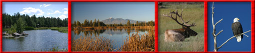
Northern Arizona and Flagstaff Attractions
Meteor Crater, Museum of Northern Arizona, Lowell Observatory, Flagstaff Arboretum, The Grand Canyon, Lake Powell, Wupatki Ruins, The Grand Canyon Railroad, The San Francisco Peaks, Arizona Snowbowl, Sunset Crater, Sedona, Oak Creek......Just to name a few.
|